
Contact
Mark VonTillow
Inspector II/Wildland Specialist
805-564-5720
MVontillow@SantaBarbaraCA.gov
Community Wildfire Protection Plan (CWPP)

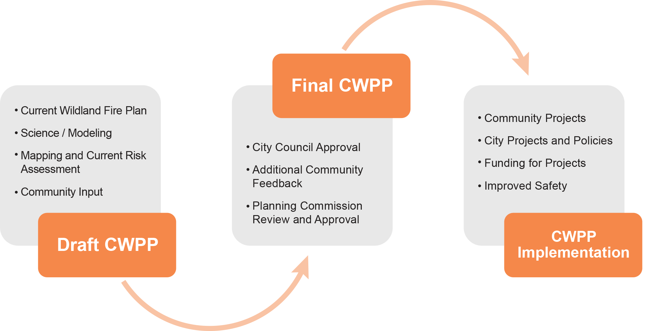
On February 9, 2021 Santa Barbara City Council unanimously adopted the 2021 Community Wildfire Protection Plan (CWPP) and certified the program Environmental Impact Report.
The CWPP provides a framework for mitigating wildland fire impacts throughout the City. This recent update was made possible through CAL FIRE Fire Prevention Grant funding and updates the City's 2004 Wildland Fire Plan.
Final Community Wildfire Protection Plan Document:
Final Program Environmental Impact Report (PEIR):
Final PEIR Appendices:
The Santa Barbara City Fire Department recently completed a update to the original 2004 Community Wildfire Protection Plan, also known as the Wildland Fire Plan, aimed at mitigating wildland fire impacts. Recent California fires that have devastated urban communities have heightened our community’s perception of our vulnerability to wildfire. Updating the existing Community Wildfire Protection Plan (CWPP) and programmatic Environmental Impact Report (EIR) was made possible thanks to a $310,000 CAL FIRE Fire Prevention Grant.
Frequently Asked Questions
A Community Wildfire Protection Plan (CWPP) is a community-based plan focused on identifying and addressing local hazards and risks from wildfire. CWPPs are authorized and defined in Title I of the Healthy Forests Restoration Act (HFRA), passed by Congress in 2003.
- A CWPP determines what is at risk and provides a roadmap of actions for a community to address the wildfire threat. A CWPP includes, at a minimum, the following 3 central components
- Collaboration - A CWPP must be collaboratively developed. Local and state officials must meaningfully involve nongovernmental stakeholders and federal agencies that manage land in the vicinity of the community.
- Prioritized Fuel Reduction - A CWPP must identify and prioritize areas for hazardous fuel-reduction treatments and recommend the types and methods of treatment that, if completed, would reduce the risk to the community.
- Treatment of Structural Ignitability - A CWPP must recommend measures that homeowners and communities can take to reduce the ignitability of structures throughout the plan area.
Santa Barbara's Wildland Fire Plan is our Community Wildfire Protection Plan (CWPP). The concept of a CWPP was relatively new and mostly unknown at the time the 2004 Wildland Fire Plan was adopted. Santa Barbara City was a leader in the early recognition of the need to have a community based plan to protect our citizens and valuable resources from wildfire. At the time the 2004 Wildland Fire Plan was adopted, Community Wildfire Protection Plans were not well known and the terminology had not been widely recognized. Over the past 15 years CWPP's have become commonplace and are recognized across the nation. In 2011, City Council formally recognized the 2004 Wildland Fire Plan as our City's Community Wildfire Protection Plan.
A CWPP is a community level planning document, not a regulatory document or ordinance.
A CWPP is not a land use, growth management, or emergency evacuation plan.
- Land use and growth management for the City of Santa Barbara is guided by the Santa Barbara General Plan (https://santabarbaraca.gov/government/priorities-policies/general-plan)
- Emergency response within the City of Santa Barbara is guided by the City's Emergency Management Plan (https://santabarbaraca.gov/sites/default/files/documents/Fire/City%20Emergency%20Plan/City%27s%20Emergency%20Management%20Plan.pdf?BlobID=39294)
- To re-assesses wildfire hazards and risks to the community.
- To guide the City in prioritizing projects and locations where the City can take action to reduce the wildfire threat in ways that are reasonable and acceptable to the community's way of life.
- To open up funding opportunities to implement the plan.
- To define values/assets and how to enhance protection to those assets in case of a wildfire. Assets at risk are unique to each community and can include homes, roads, other structures and infrastructure, wildlife habitat, or even views.
- To build and strengthen relationships among agencies and provide visibility for organizations and individuals.
- To identify new and increase awareness of existing community-level projects, e.g.: clearing vegetation from major evacuation routes; creating community chipping programs; and developing plans for fuel hazard reduction treatments around a community.
The CWPP's updated wildfire hazard data will allow staff and decision-makers to make informed policy recommendations and decisions about enhanced development standards or prohibitions of ADUs in High Fire Hazard Areas.
- To educate Santa Barbara residents about current wildfire risks and steps that can be taken to reduce those risks.
- To develop future policies and ordinances for consideration by Santa Barbara City Council as appropriate.
- To take action to implement community hazard reduction projects individually or collectively as appropriate.
- To apply for grants and other funding sources to implement hazard reduction projects.
- The Draft CWPP will be developed using the current Wildland Fire Plan, updated modeling and mapping of current wildfire risk, and community input.
- The Draft CWPP will then be revived by the public, approved by the Planning Commission and Adopted by the City Council.
- The Final CWPP will then be used to improve safety through community projects, policies, and funding programs.
A High Fire Hazard Area (HFHA) is identified as a location that has at increased risk for wildland fire. Due to a number of variables identified throughout Santa Barbara City's HFHA, our existing Community Wildfire Protection Plan recognizes four separate zones (High Fire Hazard Zones) within the HFHA. Each zone has specific requirements, such as varying distances to meet defensible space requirements.
The Wildland Fire Suppression Assessment District (WFSAD) provides services specific to residents who reside within the district boundaries. Those services include vegetation road clearance, defensible space chipping, vegetation management projects and voluntary defensible space evaluation. The district includes both the Foothill and Extreme Foothill HFHAs as outlined in the 2004 City of Santa Barbara Wildland Fire Plan. Since the establishment of the WFSAD in 2006, the Foothill High Fire Hazard Area has expanded to include multiple properties west of East Los Olivos St surrounding the Santa Barbara Mission. These parcels are not included since they were designated to be within the Foothill High Fire Hazard Area after the establishment of the WFSAD. The Coastal and Coastal Interior High Fire Hazard Areas are not included in the WFSAD.
The CWPP will assess wildfire risk and better prepare communities and homeowners for wildfires given the current risk. Please contact your insurance provider for information about your rates.
Maps

Identify if your property is located within the High Fire Hazard Area.

Map showing High Fire Hazard Area changes within the City of Santa Barbara as adopted by City Council, Feb 2021.

Map showing Vegetation Management Unit changes within the City of Santa Barbara for the 2021 CWPP update as adopted by City Council, Feb 2021 .

Map illustrating the location and extent of the Wildland Fire Suppression Assessment District (established in 2006).
Base Maps

Map showing the elevation changes and topography within the City of Santa Barbara.

Map displaying the density of structures within the City of Santa Barbara.

Map displaying the history of wildfires in and around the City of Santa Barbara.

Map displaying the history of fire ignitions in and around the City of Santa Barbara (2004-2020)

Map illustrating potential flame length within the City of Santa Barbara based on the results of Fire Behavior Modeling conducted for the 2021 CWPP update.