Flood Advisory Issued by National Weather Service
February 13, 2025 Storm Update
A Flood Advisory is in Effect Until 8:00 p.m. PST for Santa Barbara County due to excessive rainfall.
Flood Safety Tips and Resources: weather.gov/safety/flood
NO evacuations are currently in place for the City of Santa Barbara.
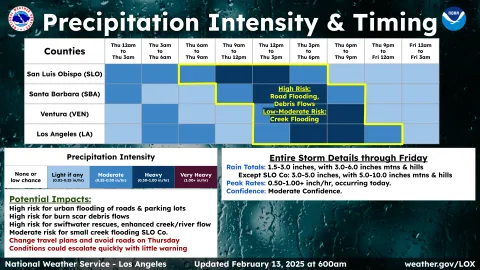
What to Expect:
- Flooding: Roadway flooding is expected, especially in low-lying and poor drainage areas. Water ponding in urban areas is occurring or imminent.
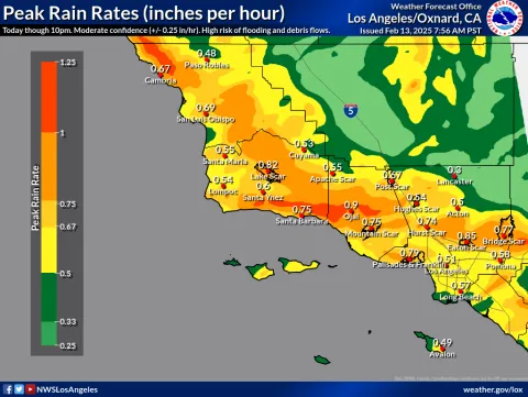
- Rainfall: Light to moderate rain is currently falling across the county. Heavier rain will arrive late this morning and continue into the evening, with rainfall rates of 0.25 to 0.50 inches per hour—possibly reaching 1.00 inch per hour near thunderstorms.
- Impacts: Flooded roads, hazardous driving conditions, and potential disruptions in affected areas.
PRECAUTIONARY/PREPAREDNESS ACTIONS:
Turn around, don't drown when encountering flooded roads. Most flood deaths occur in vehicles. Find an alternate route.
This storm also poses a potential risk for debris flows and significant flooding to residents and businesses within and surrounding the Lake Fire burn scar.
Public safety officials are keeping a close eye on the incoming storm and working with the National Weather Service. Officials will continue to work together to further assess if protective actions, such as an evacuation warning, evacuation order, or shelter-in-place are necessary.
For more information, visit ReadySBC.org.
Resources to Help You Prepare NOW:
- Check the City Storm Updates: SantaBarbaraCA.go/StormUpdates
- FREE Emergency Storm Parking for City of Santa Barbara residents in flood-prone areas through February 15: SantaBarbaraCA.gov/StormParking
- Detailed National Weather Service forecasts: https://www.weather.gov/lox/.
- Storm readiness tips: http://www.readysbc.org/StormReadiness.
- For status of highways: https://roads.dot.ca.gov/roadscell.php
- For status of County roadways: https://www.countyofsb.org/2116/Road-Closures
- For countywide sandbag filling locations: https://www.countyofsb.org/2219/Sandbags
- Sign up for ReadySBC Emergency Alerts: https://member.everbridge.net/index/892807736723794#/signup